
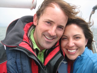
 We left San Francisco on February 10, 2010 with a plan to head south to Mexico and then make the innocently named "puddle jump" to the South Pacific (!!) this spring. From there, who knows?!?!?!? Maybe Fiji? Australia? New Zealand? For now, we're just thrilled to finally be out at sea!

After a loooongg nine-days of sailing, we finally spotted the white spray of breaking waves far off in the distance. This was our first glimpse of Beveridge Reef, a partially submerged coral reef in the middle of the ocean. As we got closer, Matt pointed out the lagoon, a flat shimmering line just beyond the horizon. We could see a flash of silver as sunlight reflected off a wreck located on the eastern edge of the reef. We were only a few miles from the pass when I turned my head just in time to see a humpback whale breach far out in front of us and then I suddenly started to see spouts everywhere! There was a group of whales up ahead of us and we were treated to a (distant) show of huge flukes and flippers. There were a few spouts much closer to us and every once in a while we’d catch a glimpse of a black shiny back as the whales slowly moved west. These were the first whales we have seen on the entire sailing trip so I was quite excited!!
The pass was quick and simple, but we had done our research – it could be all too easy to end up on the reef if you didn’t know exactly where you were going (see my navigation notes below). We anchored just to the southwest of the pass inside the lagoon. There is a white sand shelf that runs all around the inside of the reef and we dropped the hook in 10 feet! The max depth of the shelf appeared to be about 12-13 feet before it dropped off swiftly to 30. At one point, Matt commented that if, for some reason, we dragged anchor, we could probably float all across the lagoon and would catch ourselves on the far shelf before hitting the reef. I laughed and said, well if we drag anchor off the shelf, we’ll just have a 3:1 scope instead of a 10:1! But the holding on the shelf is excellent. The only place we encountered potentially dangerous (aka shallow) coral heads was at the north side of the reef and even then, we easily found a large patch of sand where we could anchor and swing around without hitting anything.
We were the only boat in the lagoon (!) so we had our choice of anchorages. The first anchorage we stayed at, just to the southwest of the pass, was nice and the best part was that I could sit on the foredeck and watch some whales frolicking just on the other side of the reef! The snorkeling there wasn’t all the awesome though. We went closer to the reef and there was some interesting stuff, but overall I was disappointed. There was very little live coral but it was fun to play with the fish. Jon had taken the dinghy over to the south side of the pass to see whether it would be good to dive/snorkel there. He said the current was pretty strong but it could be a good place to explore. So the three of us went out there the next afternoon, Jon with his dive gear and us with our snorkels, and it was pretty sweet. The pass is full of underwater canyons and this was the first time Matt and I had seen this kind of geography, so we were quite impressed! There were hundreds of fish, but not much variety. We saw lots of 2.5 ft long parrot fish and schools of large silvery fish. There were a few sharks wandering around too. The current was really strong and I’m not exactly the best swimmer – even with my fins! – so I hung onto a dinghy line and just floated around. Not moving that much, though, I ended up surrounded by dozens of fish that were hanging out just below the surface. I would turn slowly and be face to face with a fish! Matt was videotaping the scene and Jon as he dove and we spent a good hour out there not going more than 20ft from the dinghy.
The second place we anchored was on the eastern side of the reef next to the wreck (a 35ft fishing boat). We went and explored that but the swell coming over the reef and the shallow depth in that area made it impossible to snorkel or drive around with the dinghy. We tried snorkeling around our boat the next day but the area was mostly sand and the only interesting thing we saw was a sting ray. Plus, we were exhausted within minutes trying to battle the swell.
After one night there, we decided to take the boat to the north western side of the reef just for the day to check out the north side of the pass. The lagoon is only about 3 miles east-west, so moving around isn’t a big deal. We anchored again in 9 feet of water, coming close to running aground at one point as the depth meter read only 7 feet!! Our draft is 6.5! We turned around and went back to the “deeper” area and it was quite strange to feel comfortable with less than 5 feet under the keel!
We dinghied out to the northern side of the pass and were trying to find a place to anchor the dinghy. The second time I stuck my face in the water to look around, I found myself surrounded by flashing fish and sharks! I signalled to Matt and came up, eyes wide, saying “Wow! That is awesome! Wow! That is awesome!” We threw out the dinghy anchor and hopped in. We were in a narrow canyon-like area and there were at least two dozen sharks and thousands of fish hanging out in the current. We stayed around there for about an hour, watching the sharks and chasing the massive schools of fish. It really is incredible how they all turn and group and move at the same time. Their innate choreography is amazing. How do they know?!?! Even though there were more sharks in this water than anyplace we’ve been before, I told myself they weren’t interested in me and I actually let go of the dinghy line and ventured farther out. The current was so strong though, that I eventually went back just to rest! After we got “bored,” we decided to drift through the pass. We retrieved the dinghy anchor and then headed further into the lagoon just to the edge of the pass. We then held onto the dinghy and let the current push us. This ended up being rather unexciting. We saw more fish/sharks/cool geography in the other two areas than we did going across the whole pass! It’s like the current pushed us through the least interesting path. By that time, Jon had run out of air in his scuba tank and we were all cold, so we went back to the boat and headed across the lagoon again to anchor on the north side of the reef.
As we headed over, we saw a pod of dolphins crossing the lagoon. It was a bit tricky coming in because there were a significant amount of coral heads, indicated by dark shadowy spots on the water. Most, if not all of them, were easily more than 10 feet below the surface but when the water is so clear, one’s depth perception is seriously thrown off. We carefully motored onto the sand shelf and again set the anchor in 10 feet of perfect sandy bottom. For snorkeling purposes, this was the best place we went to. Easily the most spectacular coral we’ve seen on the entire trip!!! We took the dinghy out a little bit closer to the reef and checked out some of the larger coral heads. We found a large coral garden and it was amazing. I can’t get over how pretty the coral can be. The colors, the variety… This one, too, had a greater variety of fish than we had seen around the other anchorages and there were moray eels hanging out in their dark little holes along the outer ridges. Most of the coral there was too shallow for us to snorkel over it, but there were a few narrow paths into the garden and we snuck in and thoroughly enjoyed pretending to be fish 🙂 We went fairly early in the day and it was so pretty to see the sunlight reflecting on the coral. It made the colors shimmer like a rainbow. I’ve never seen anything like it!!
We were fortunate to have relatively good weather for the four days we were there and we also happened to have a full moon, which just made the whole scene that much more awesome at night. To wake up at 2am, go on deck and see nothing but ocean for miles under brilliant moonlight and know that we are safely anchored in 10 feet?!!?! Yeah. 🙂
We knew we had to get a move on, though, and we had seen just about everything there was to see (uh huh!), so on the 5th day, we took some cool underwater video of the boat and then packed up and headed for Tonga. Matt should be posting the videos from Bev Reef one of these days….

This shows the shallow sand shelf around the edge of the reef and the deeper blue is the steep drop-off to 30ft+


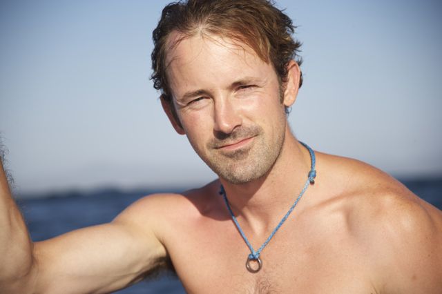
Matt snorkeling on the edge


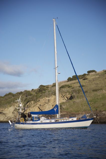
another view from the spreaders


anchored in the middle of the ocean
_____________________________________________________________________
***Navigation Notes (waypoints are in degrees decimal minutes)
Arriving from the east, we kept this waypoint to port as we sailed around the north part of the reef:
19.57.008 S, 167.46.006 W
We turned left into the pass at waypoint: 19.57.394 S, 167.47.433 W (sorry, I don’t have our heading!)
We anchored at the following waypoints (in less than 15 feet and as little as 9 feet):
20.00.74 S, 167.46.67 W (in the lagoon, just south of the pass)
20.00.013 S, 167.44.64 W (on the eastern side of the lagoon, near the wreck)
19.59.507 S, 167.46.137 W (on the western side of the lagoon, north of the pass; we anchored here just for a few hours, but the holding was fine – all sand – and would be good in westerly winds although I don’t remember whether we were so close to the pass as to have that portion of the reef be a potential issue)
19.58.921 S, 167.44.617 W (north end of the lagoon, more coral heads to watch out for but best snorkeling!)
We had consistent winds while we were there, but varying from NE/E/SE. Swell was minimal, but it did seem to sneak over the reef a little bit, particularly on the eastern side.
**Matt and I have used Google Earth a lot over the last couple of years to check out places to camp so it was no surprise that we have been using it to virtually explore islands before we sailed to them. In fact, Matt came across a program that allowed him to impose our navigation charts over a google earth image. This has come in handy to check how accurate our charts are and to “see” where we can anchor, any obstacles to watch out for, etc. Well, when we were in Huahine and researching Beveridge Reef, we checked Google Earth and to our shock, Google Earth did not have images of the reef. Yeah – it’s that remote and bizarre.
Karen, it LOOKS AMAZING! I’m so jealous.